Coldbrook Flooding - History
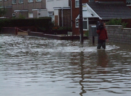
On 20th July 2007, Barry, together with a number of other locations in the Vale of Glamorgan, was subjected to intense rainfall. Significant flooding of properties and roads was reported as watercourses and land drainage systems were unable to cope with the intensity of the event.
One of the most significant areas of flooding was along the route of the Coldbrook watercourse which runs from the Colcot area through the town's districts of Gibbonsdown, Cadoxtan and Palmerston to the open stream adjacent to the A4231 Barry Docks Link Road.
In all, approximately 100 residential properties and four schools were flooded along the route of the watercourse or within its catchment area. Some of the properties were so badly affected by the floods that the residents were unable to return to their properties for 6 months.
Shortly after the flooding incident in July 2007, a Flood Risk Management Group was formed to look specifically into flooding in the area. The group comprised local residents, Elected Members and Officers of the Local Authority, the Welsh Assembly Government, Dwr Cymru Welsh Water, the Environment Agency Wales (now Natural Resources Wales) and other relevant authorities. The objectives of the Group were to draw up a comprehensive risk management plan for the urban drainage area and develop this plan in order that it can be understood by both the system operators and the public it serves.
At the same time, the Vale of Glamorgan Council undertook a fact-finding exercise with residents who had been affected by the incident being invited to complete a questionnaire entitled “Flooding Incident – 20th July 2007”. The questionnaire asked householders for detailed information about the incident itself, its effects on their property and the consequences. The objective was to use the information collected to better inform plans to manage and reduce the risk of a re-occurrence. In all there was a 59% response rate which yielded much useful and detailed information, proving essential to the procedure in hand.
This response to the July flood event and the general approach of the Council to future flood risk in the catchment, aligned itself with the Welsh Government’s desire to move towards a risk management approach whereby flood risk is managed holistically.
The Council proposed that a study of the flood risk issues in the Coldbrook catchment be carried out and consequently Welsh Government accepted the proposals as part of a national pilot study that would also assist in the development of future guidance and best practice in Wales.
In November 2007 the Welsh Government approved funding to carry out a Pre-Feasibility Study (PFS) of the Coldbrook catchment. The study was undertaken by the Vale of Glamorgan Council and completed in autumn 2008. It identified a number of potential improvement options and recommended that further, more detailed investigations be carried out to establish the viability of undertaking a capital improvement scheme.
In 2010 a more detailed Project Appraisal Report (PAR) was commissioned by the Council and was subsequently completed by Martin Wright Associates. In preparing the PAR, all available information was assessed and an initial hydraulic computer model of the drainage system in the area was produced and used to examine potential options for reducing flood risk. A cost benefit analysis and options appraisal concluded that a capital works project was viable.
The findings of the PAR were submitted to Welsh Government and the project was accepted as suitable for Welsh Government grant aid. It was also included as one of a small number of schemes across Wales that would also be eligible for EU Competitiveness funding.
TAN 15 Development and Flood Risk Advice Map
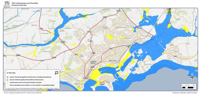
Also available on the Development Advice Maps for Wales website.