Cost of Living Support Icon

Five Mile Lane Improvements Project

The Five Mile Lane Improvements Project aims to improve safety along the existing A4226 (Five Mile Lane) 


The existing road is a single carriageway road. The scheme involves a combination of improvements including:

  • Construction of a new road that bypasses the winding central section of the existing road.

  • Improved access and safety for non-motorised users in the form of a bridge and combined footway and cycleway.

  • Works to improve the drainage for the existing carriageway.

  • Introduction of 60mph speed limit from Sycamore Cross to the Welsh Hawking Centre.

  • Safe crossing for equestrian users.


The existing road will remain open after the scheme is completed to provide local access to various farms along its length and as a safer route option for non-motorised users. The only vehicular access to and from this road will be from the three proposed junctions linking to the new road. All other footpaths and street lighting along the existing Five Mile Lane will remain unchanged.


  • Bridleway

    The design submitted for planning permission incorporates a new bridleway which runs from an access point on part of the existing A4226 and will run northwards on the western side of the new road scheme, over a newly constructed bridge at Sutton farm and will continue northwards on the eastern side of the new road up to the side road adjacent Northcliffe Cottage. This will provide a safe route for both pedestrians and horses. 
  • Cycleway/footway

    Proposed route would run from Weycock roundabout up to the layby but on the western side. Then via the old Five Mile lane (which is being closed to vehicular traffic at either end). Then a new cycleway/footway from Blackland farm up to Sycamore cross, again on the western side. 

Progress Updates


  • 12 September 2019

    The new road has been opened to traffic to allow work on the tie in sections/junctions to be completed.

    In addition, the four planned weekend road closures are still due to go ahead to allow the last quantity of surfacing to be laid.


    There will be some tree planting in the upcoming months.


  • 07 August 2019

    Griffiths attended this year's Vale of Glamorgan Agricultural Show where they shared plans and updates with visitors. 


    Griffiths-at-Vale-Show


  • June 2019


    • The centre and southern sections have now been completed.

    • Work on the north section is due to commence soon and includes the redesign of the bus stop pull in. 

    • Work being undertaken by water and electricity companies are connected to the new road construction works currently under way on Five Mile Lane.

    • There have been ongoing technical issues with an old large asbestos water main which serves a significant number of properties in the Barry, Rhoose and airport area. These are currently being addressed by Welsh Water whilst they are still maintaining water supplies to properties and businesses in the area.  These water works are due to be completed by early July.  


    Bridge
    Central-section


    Section-by-bridge
    Trees-on-five-mile-lane


  • December 2018

     
  • October 2018

    The results of good summer weather are evident on site. The large operation to move 100,000m3 of material offline to form the new road profile was completed ahead of programme.


  • August 2018

    View of the road near Sutton Fach Farm, showing ongoing top soiling of the banking and installation of lined drainage channels.

    Topsoiled cut area viewed south from Ch2800
    Topsoiled cut as viewed south from Ch 2550

    Sycamore Cross


  • July 2018

    The Topsoil Strip has been completed across the majority of the site and bulk excavation has now started at Sutton Fach Farm. Excavation work has also commenced on drainage ponds throughout the project. All Archaeology work has now finished with the exception of the area between the Hawking Centre and Weycock roundabout.


    bulk excavation at Sutton Fach Farm.
    topsoil strip on the proposed new road.


Plans and Documents

On 25 January 2016 the Council resolved to make both the Compulsory Purchase Order and the Side Roads Order for the purposes of facilitating the delivery of a scheme of construction, improvement and other works to improve the A4226 Five Mile Lane .


Five Mile Lane Documents

Beech TreeLandscape and Biodiversity 

A key component of the scheme will be its landscape and biodiversity design. Existing trees, woodland and hedgerows will be retained wherever possible to help mitigate any adverse landscape, visual amenity and ecological impacts. Work will include the planting of:

  • Broadleaf woodland

  • Native mixed-species hedgerows

  • Individual trees

  • Species-rich and amenity grassland

  • Earthworks

Land adjacent to the Scheme will be planted with locally present native woodland species to mitigate for the loss of habitat and provide screening and landscape integration.

North Range SMR  16bArchaeological Work

Rubicon Heritage commissioned by the Vale of Glamorgan Council to undertake a programme of archaeological investigation associated with the A4226 road improvement scheme.


Throughout the archaeological project Rubicon liaised with the National Museum of Wales, Cardiff University and Cadw with representative of all three institutions visiting the sites during excavation work. 


The project has provided a wide range of very significant evidence for the archaeology and history of the area from early prehistory (3500BC) through to the Roman period (1st to 4th centuries AD).


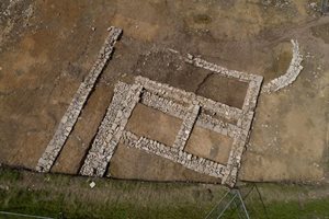
Archaeological Work on Land at Five Mile Lane


Prior to and during the initial road works to improve the A2226, Rubicon Heritage Services Ltd investigated the Five Mile Lane Site.


Following the investigation, an initial archaeological report on the works undertaken between 2017-2019 has been published into an archaeological e-book report.


The report provides an overview of the site, its chronology, its landscape, and the initial findings relating to the people who lived and farmed the land from the late Bronze Age to Roman times.


It provides an exciting initial guide to what was found and our understanding of history at the site.


Following the completion of further detailed analysis by various experts, a more detailed academic study will be published in late 2022.


Archaeology Report   Interactive Story Map